2.—(1) Part 1 of the First Schedule to the Active Mobility (Shared Paths) Order 2018 (G.N. No. S 260/2018) (called in this Order the principal Order) is amended by inserting, immediately after item 17, the following items: | “18. | A path (approximately 0.14 kilometre in length) starting at bus stop number 54199 near Block 163 Ang Mo Kio Avenue 4, running along Ang Mo Kio Avenue 4 and ending at Mayflower Avenue. |
|
| 19. | A path (approximately 0.24 kilometre in length) starting at Mayflower Avenue, running along Ang Mo Kio Avenue 4 and ending at Ang Mo Kio Street 11. |
|
| 20. | A path (approximately 0.10 kilometre in length) starting at Ang Mo Kio Street 11, running along Ang Mo Kio Avenue 4 and ending at bus stop number 54189 near Block 110 Ang Mo Kio Avenue 4. |
|
| 21. | A path (approximately 0.12 kilometre in length) starting at Ang Mo Kio Avenue 4, running along Ang Mo Kio Street 13 and ending at lamp post 14 near Block 170 Ang Mo Kio Street 13. |
|
| 22. | A path (approximately 0.18 kilometre in length) starting at Lentor Hill Road, running along Lentor Drive and ending at Yio Chu Kang Road. |
|
| 23. | A path (approximately 0.18 kilometre in length) starting at Lentor Loop, running along Lentor Drive and ending at Yio Chu Kang Road. |
|
| 24. | A path (approximately 0.23 kilometre in length) starting at Lentor Drive, running along Yio Chu Kang Road and ending at bus stop number 55021. |
|
| 25. | A path (approximately 0.23 kilometre in length) starting at Lentor Drive, running along Yio Chu Kang Road and ending at bus stop number 55011. |
|
| 26. | A path (approximately 0.17 kilometre in length) starting at Mayflower MRT Station Exit E along Ang Mo Kio Avenue 4, running along Yio Chu Kang Road and ending at bus stop number 55019. |
|
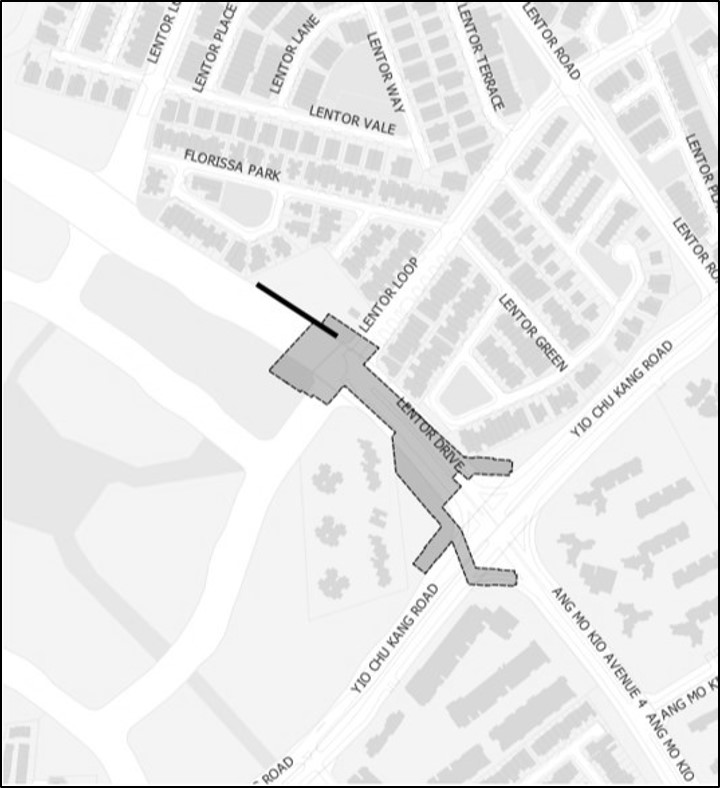
| 27. | A path (approximately 0.06 kilometre in length) on Lentor Drive (southbound) and ending at the junction of Lentor Loop and Lentor Hill Road, as delineated by the black‑coloured line in the map set out below. |
|
| 28. | A path (approximately 0.05 kilometre in length) on Lentor Drive (northbound) and ending at the junction of Lentor Loop and Lentor Hill Road, as delineated by the black‑coloured line in the map set out below.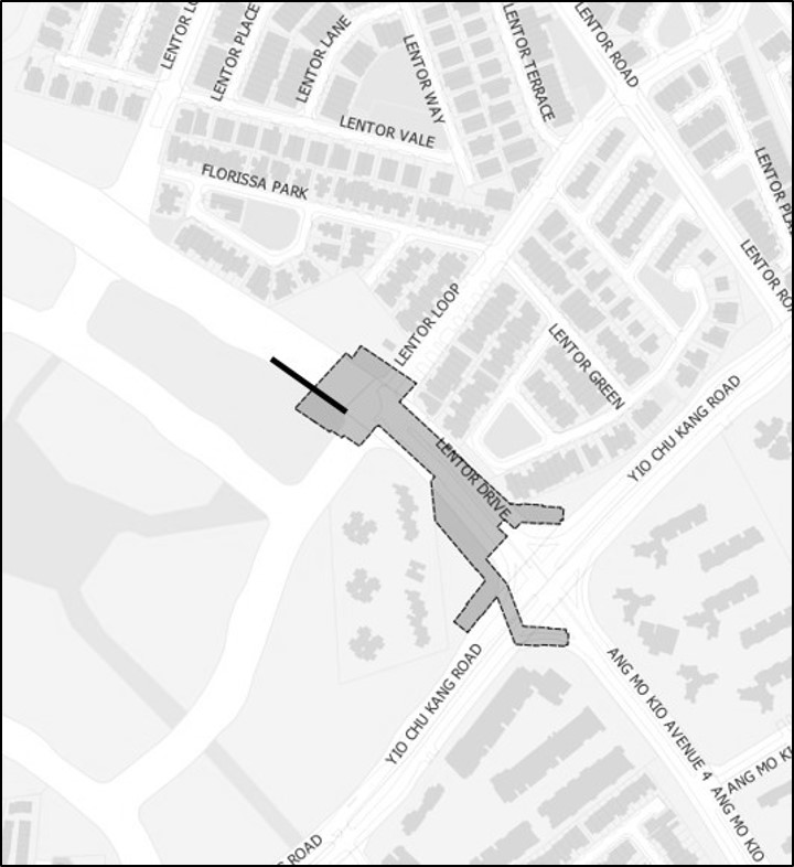 ”. ”. |
|
|
|
(2) Part 8 of the First Schedule to the principal Order is amended by inserting, immediately after item 5, the following item: | “6. | A path (approximately 0.30 kilometre in length) starting at Hougang Avenue 4, running along Hougang Street 61 and ending at Hougang Avenue 8.”. |
|
|
|
(3) Part 9 of the First Schedule to the principal Order is amended —| (a) | by deleting item 7 and substituting the following item: | “7. | A path (approximately 0.36 kilometre in length) starting at Jurong East Street 24, running along Jurong East Avenue 1 and ending at the access leading to All Saints Home (excluding the path behind bus stop number 28329 near Block 246).”; and |
|
|
| | (b) | by inserting, immediately after item 53, the following item: | “54. | A path (approximately 0.12 kilometre in length) starting at the junction of Jurong Gateway Road and Jurong East Central 1, running along Jurong East Central 1 and ending at Jurong Regional Library.”. |
|
|
|
|
(4) Part 11 of the First Schedule to the principal Order is amended by inserting, immediately after item 5, the following items: | “6. | A path (approximately 0.39 kilometre in length) starting from the entrance to Marina Barrage, running to and within Marina Barrage Central Courtyard and ending at the part of Marina Barrage that is adjacent to Gardens by the Bay South. |
|
| 7. | A path (approximately 0.07 kilometre in length) starting from the part of Marina Barrage that is adjacent to Marina Bridge and ending at the point where it intersects with the path described in item 6 of this Part. |
|
| 8. | A path (approximately 0.45 kilometre in length) on the Marina Bridge, as delineated by the black‑coloured line in the map set out below.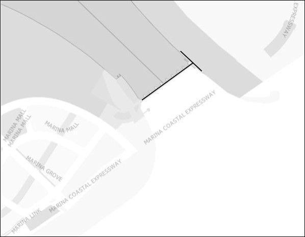 ”. ”. |
|
|
|
|
(5) Part 13 of the First Schedule to the principal Order is amended by inserting, immediately after item 27, the following item: | “28. | A path (approximately 0.16 kilometre in length) starting at Pasir Ris Drive 3 near the pedestrian crossing with lamp post 182, running along Pasir Ris Drive 3 and ending at Sungei Api Api River near lamp post 172.”. |
|
|
|
(6) Part 17 of the First Schedule to the principal Order is amended by inserting, immediately after item 20, the following items: | “21. | A path (approximately 0.14 kilometre in length) starting at the intersection of Canberra Lane and Canberra Link, running along Canberra Lane and ending at the intersection of Canberra Lane and Canberra Drive. |
|
| 22. | A path (approximately 0.32 kilometre in length) starting at the intersection of Canberra Lane and Canberra Drive, running along Canberra Drive and ending at the intersection of Canberra Drive and Sembawang Road. |
|
| 23. | A path (approximately 0.13 kilometre in length) starting at the intersection of Canberra Drive and Sembawang Road, running along Sembawang Road and ending at the intersection of Canberra Road, Sembawang Road and Sembawang Avenue. |
|
| 24. | A path (approximately 0.10 kilometre in length) starting at the intersection of Canberra Road, Sembawang Road and Sembawang Avenue, running along Sembawang Road and ending at the intersection of Sembawang Road and Jalan Sendudok. |
|
| 25. | A path (approximately 0.30 kilometre in length) starting at the intersection of Sembawang Road and Jalan Sendudok, running along Sembawang Road and ending at the intersection of Sembawang Road and Jalan Jeruju. |
|
| 26. | A path (approximately 0.62 kilometre in length) starting at the intersection of Canberra Lane and Canberra Drive, running along Canberra Drive and ending near lamp post 58F. |
|
| 27. | A path (approximately 0.72 kilometre in length) starting at the junction of Sembawang Road and Canberra Street, running along Canberra Street and ending at the junction of Canberra Street and Canberra Way. |
|
| 28. | A path (approximately 0.21 kilometre in length) starting at the junction of Canberra Street and Canberra Way, running along Canberra Street and ending near lamp post 40. |
|
| 29. | A path (approximately 0.30 kilometre in length) starting at the junction of Canberra Crescent and Canberra Walk, running along Canberra Crescent and ending at the junction of Canberra Crescent and Canberra Way. |
|
| 30. | A path (approximately 0.21 kilometre in length) starting at the junction of Canberra Crescent and Canberra Way, running along Canberra Crescent and ending at the junction of Canberra Crescent and Canberra View. |
|
| 31. | A path (approximately 0.22 kilometre in length) starting at the junction of Canberra Way and Canberra Link, running along Canberra Link and ending at the junction of Canberra Link and Canberra View. |
|
| 32. | A path (approximately 0.18 kilometre in length) starting at the junction of Canberra Link and Canberra Way, running along Canberra Way and ending at the junction of Canberra Way and Canberra Crescent. |
|
| 33. | A path (approximately 0.32 kilometre in length) starting at the junction of Canberra Crescent and Canberra Way, running along Canberra Way (eastbound) and ending at the junction of Canberra Way and Canberra Street. |
|
| 34. | A path (approximately 0.17 kilometre in length) starting at the junction of Canberra Street and Canberra Way, running along Canberra Way (eastbound) and ending at Canberra Way near Block 121C.”. |
|
|
|
(7) Part 20 of the First Schedule to the principal Order is amended by inserting, immediately after item 35, the following items: | “36. | A path (approximately 0.61 kilometre in length) starting at Tampines Avenue 5, running along Tampines Avenue 8 and ending at Tampines Street 84. |
|
| 37. | A path (approximately 0.20 kilometre in length) starting at Tampines Street 84, running along Tampines Avenue 8 and ending at Tampines Avenue 3. |
|
| 38. | A path (approximately 0.32 kilometre in length) starting at Tampines Avenue 3, running along Tampines Avenue 8 and ending at Tampines Avenue 1. |
|
| 39. | A path (approximately 1.13 kilometres in length) starting at Tampines Avenue 8, running along Tampines Avenue 1 and ending at Tampines Avenue 4. |
|
| 40. | A path (approximately 0.18 kilometre in length) starting at Tampines Avenue 1, running along Tampines Avenue 4 and ending at Tampines Street 91 near Block 802. |
|
| 41. | A path (approximately 0.18 kilometre in length) starting at Tampines Street 91 near Junyuan Primary School, running along Tampines Avenue 4 and ending at Tampines Street 91 near the former East View Primary School. |
|
| 42. | A path (approximately 0.22 kilometre in length) starting at lamp post 33 along Simei Road, running along Simei Road and ending at the junction of Simei Road and Upper Changi Road East.”. |
|
|
|
(8) Part 21 of the First Schedule to the principal Order is amended by inserting, immediately after item 2, the following item: | “3. | A path (approximately 0.52 kilometre in length) starting at the junction of Lorong 6 Toa Payoh and Toa Payoh East, running along Toa Payoh East and Lorong 5 Toa Payoh and ending at the junction of Lorong 4 Toa Payoh and Lorong 5 Toa Payoh.”. |
|
|
|
(9) Part 22 of the First Schedule to the principal Order is amended by inserting, immediately after item 39, the following items: | “40. | A path (approximately 0.26 kilometre in length) starting at the intersection of Yishun Avenue 4 and Yishun Ring Road, running along Yishun Ring Road and ending before bus stop number 59439 along Yishun Ring Road. |
|
| 41. | A path (approximately 0.30 kilometre in length) starting at the intersection of Yishun Avenue 6 and Yishun Street 42, running along Yishun Avenue 6 and ending at the intersection of Yishun Avenue 6 and Yishun Avenue 1.”. |
|
|
|
(10) Part 23 of the First Schedule to the principal Order is amended by inserting, immediately after item 6, the following item:| “7. | A path (approximately 0.26 kilometre in length) starting at the junction of Woodlands Avenue 12 and Woodlands Avenue 12 (minor road), running along Woodlands Avenue 12 (minor road) and along an open space and ending at the junction of Woodlands Drive 75 and Woodlands View.”. |
|
|
|
(11) Part 24 of the First Schedule to the principal Order is amended by inserting, immediately after item 1, the following item:| “2. | A path (approximately 0.53 kilometre in length) starting at the junction of Jelapang Road and Saujana Road, running along Saujana Road and ending at Fajar Road.”. |
|
|
|
|