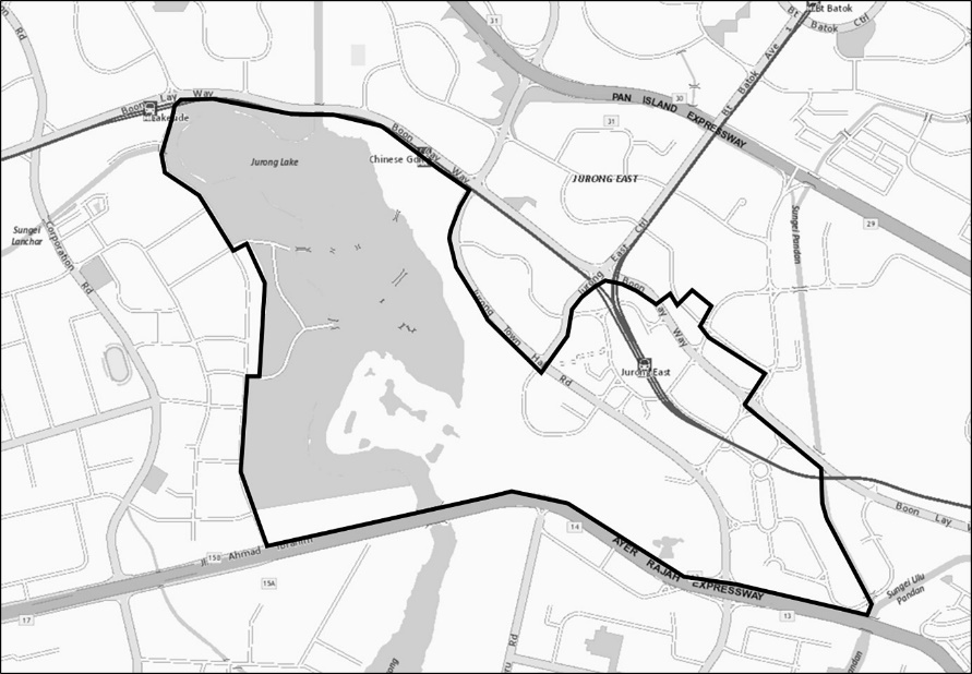
| | “(e) | all that area the boundary of which starts at the junction between Boon Lay Way and Jurong Town Hall Road and continuing progressively — |
|
|
| | (i) | Generally south‑east along Jurong Town Hall Road until its junction with Jurong East Central; |
|
|
| | (ii) | Generally north along Jurong East Central until its junction with Boon Lay Way; |
|
|
| | (iii) | Generally east along Boon Lay Way until the west corner of Lot MK05‑08852W; |
|
|
| | (iv) | Generally north‑east along the north‑western and north‑eastern perimeter of Lot MK05‑08852W until the west corner of Lot MK05‑08728M; |
|
|
| | (v) | Generally along the north‑western, north‑eastern and south‑eastern perimeter of Lot MK05‑8728M to the junction of Jurong Gateway Road and Jurong East Street 21; |
|
|
| | (vi) | Generally east along Jurong East Street 21 to its junction with Toh Guan Road; |
|
|
| | (vii) | Generally south along Toh Guan Road and Jurong East Street 11 to its junction with Boon Lay Way; |
|
|
| | (viii) | Generally south‑east along Boon Lay Way until the north‑eastern perimeter of MK05‑09275W; |
|
|
| | (ix) | Generally along the north-eastern perimeter of MK05-09275W and the eastern perimeter of MK05-09034M to the Ayer Rajah Expressway; |
|
|
| | (x) | Generally west along Ayer Rajah Expressway until its junction with Yuan Ching Road; |
|
|
| | (xi) | Generally north along Yuan Ching Road until the south‑west corner of Lot MK06‑00813V; |
|
|
| | (xii) | Generally east along the southern perimeter of Lot MK06‑00813V until the south‑east corner of Lot MK06‑00813V; |
|
|
| | (xiii) | Generally north along the eastern perimeter of Lots MK06‑00813V, MK06‑01164V and MK06‑01080T; |
|
|
| | (xiv) | Generally west along the northern perimeter of Lot MK06‑01080T until Yuan Ching Road; |
|
|
| | (xv) | Generally north along Yuan Ching Road until its junction with Boon Lay Way; and |
|
|
| | (xvi) | Generally east along Boon Lay Way until its junction with Jurong Town Hall Road, |
|
|
| | | and which is more particularly demarcated in the map below: |
|
|
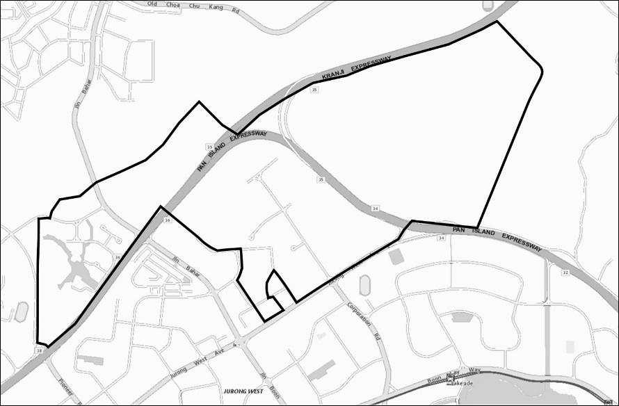
| | (f) | the area known as Jurong Innovation District which is more particularly demarcated in the map below: |
|
|
| |
| | (g) | the area known as One‑north which is more particularly demarcated in the map below: |
|
|
| |
| | (h) | all that area the boundary of which starts at the intersection of Nee Soon Flyover and Seletar Expressway and continuing progressively — |
|
|
| | (i) | Generally east along Mandai Road until its junction with Upper Thomson Road; |
|
|
| | (ii) | Generally south along Upper Thomson Road until its junction with Seletar Expressway; and |
|
|
| | (iii) | Generally north‑west along Seletar Expressway until its intersection with Nee Soon Flyover, |
|
|
| | | and which is more particularly demarcated in the map below: |
|
|
| |
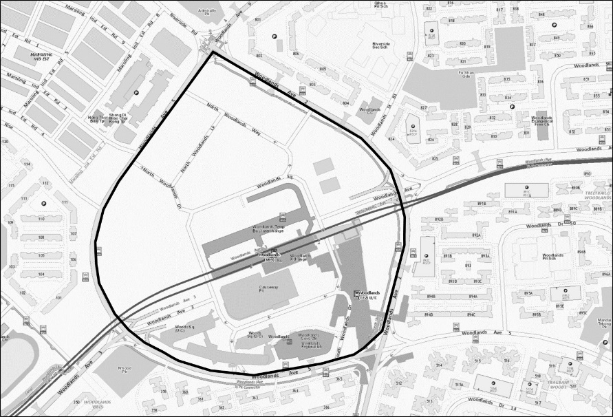
| | (i) | all that area which is bounded by Woodlands Avenue 2 and Woodlands Avenue 5, and which is more particularly demarcated in the map below: |
|
|
| |
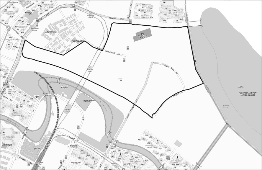
| | (j) | the area known as Punggol Digital District which is more particularly demarcated in the map below: |
|
|
| |
| |
| | 1. | For the purposes of this Part, the plans showing the areas described in item 4(f), (g) and (j) are available for inspection in such manner and at such times as may be specified by the Authority’s Development and Building Control Division.”. |
|
|


