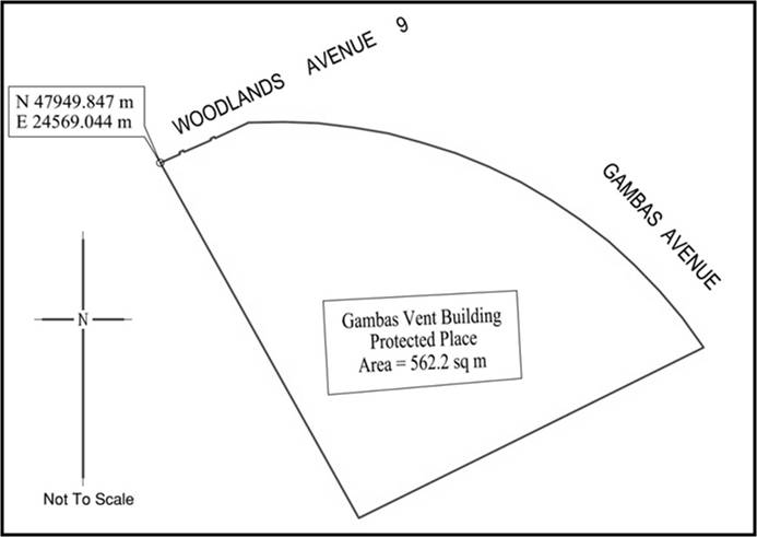
All that area comprised in part of Lot 5422C ‑MK13, along Woodlands Avenue 9 occupied by “Gambas Vent Building” containing an area of about 562.2 square metres and bounded approximately as follows:
Commencing at the corner of the aforesaid “Gambas Vent Building” which point is 47949.847 metres North and 24569.044 metres East of the Singapore Land Authority SVY 21 Datum, the boundaries run along successive lines of co‑ordinates approximately as follows:
Northing
Easting
47949.847
24569.044
47936.159
24576.671
47925.525
24582.602
47930.895
24593.435
47937.209
24606.152
47939.241
24604.693
47941.081
24603.133
47942.822
24601.451
47944.455
24599.677
47945.936
24597.750
47947.284
24595.746
47948.528
24593.663
47949.582
24591.490
47950.498
24589.250
47951.213
24586.952
47951.857
24584.628
47952.264
24582.248
47952.559
24579.847
47952.645
24577.503
47952.599
24575.072
47951.530
24572.793
47951.629
24572.745
47951.500
24572.468
47951.401
24572.517
47951.362
24572.436
47950.646
24570.810
47950.584
24570.672
47950.699
24570.620
47950.568
24570.345
47950.439
24570.403
to the point of commencement.
The boundaries of “Gambas Vent Building” are more particularly delineated on the Survey Plan set out below.
First column
Second column
The Authority
Protected Place
Managing Director, SP Powergrid Ltd
(2)
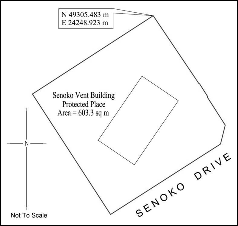
Senoko Vent Building.
All that area comprised in part of Lot 5269N ‑MK13, along Senoko Drive occupied by “Senoko Vent Building” containing an area of about 603.3 square metres and bounded approximately as follows:
Commencing at the corner of the aforesaid “Senoko Vent Building” which point is 49305.483 metres North and 24248.923 metres East of the Singapore Land Authority SVY 21 Datum, the boundaries run along successive lines of co‑ordinates approximately as follows:
Northing
Easting
49305.483
24248.923
49293.944
24231.187
49292.109
24228.367
49291.046
24229.055
49279.739
24236.369
49271.548
24241.662
49283.569
24260.376
49286.793
24261.186
49291.636
24258.110
49291.690
24258.195
49291.940
24258.029
49293.638
24256.955
49293.887
24256.797
49293.847
24256.737
to the point of commencement.
The boundaries of “Senoko Vent Building” are more particularly delineated on the Survey Plan set out below.
First column
Second column
The Authority
Protected Place
Managing Director, SP Powergrid Ltd
(3)
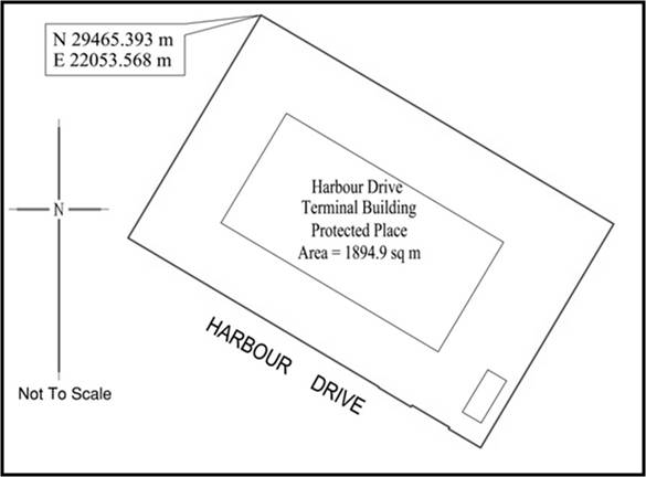
Harbour Drive Terminal Building.
All that area comprised in part of Lot 3920A ‑MK3, along Harbour Drive occupied by “Harbour Drive Terminal Building” containing an area of about 1894.9 square metres and bounded approximately as follows:
Commencing at the corner of the aforesaid “Harbour Drive Terminal Building” which point is 29465.393 metres North and 22053.568 metres East of the Singapore Land Authority SVY 21 Datum, the boundaries run along successive lines of co‑ordinates approximately as follows:
Northing
Easting
29465.393
22053.568
29452.393
22045.820
29435.678
22035.866
29425.889
22052.312
29415.810
22069.266
29415.718
22069.216
29413.129
22073.563
29413.359
22073.706
29410.410
22078.691
29410.203
22078.571
29409.943
22079.010
29409.932
22079.055
29407.674
22082.845
29409.573
22083.950
29421.242
22090.900
29437.551
22100.564
29445.669
22086.913
29453.116
22074.429
to the point of commencement.
The boundaries of “Harbour Drive Terminal Building” are more particularly delineated on the Survey Plan set out below.
First column
Second column
The Authority
Protected Place
Managing Director, SP Powergrid Ltd
(4)
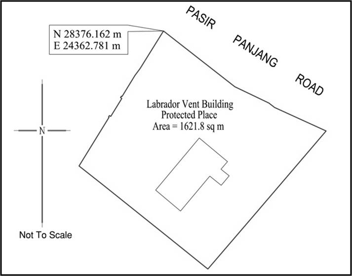
Labrador Vent Building.
All that area comprised in part of Lot 3719V ‑MK03, along Pasir Panjang Road occupied by “Labrador Vent Building” containing an area of about 1621.8 square metres and bounded approximately as follows:
Commencing at the corner of the aforesaid “Labrador Vent Building” which point is 28376.162 metres North and 24362.781 metres East of the Singapore Land Authority SVY 21 Datum, the boundaries run along successive lines of co‑ordinates approximately as follows:
Northing
Easting
28376.162
24362.781
28367.307
24357.258
28365.682
24356.045
28360.723
24352.992
28360.711
24352.985
28360.796
24352.843
28360.461
24352.636
28360.269
24352.957
28359.729
24352.616
28356.038
24350.343
28356.032
24350.340
28356.224
24350.019
28355.890
24349.811
28355.818
24349.929
28355.497
24349.731
28344.340
24342.859
28339.899
24348.499
28327.294
24364.256
28320.115
24373.175
28320.060
24373.243
28320.148
24373.320
28334.121
24385.321
28352.598
24401.116
28358.128
24388.969
28359.177
24387.630
28363.024
24379.603
to the point of commencement.
The boundaries of “Labrador Vent Building” are more particularly delineated on the Survey Plan set out below.
First column
Second column
The Authority
Protected Place
Managing Director, SP Powergrid Ltd
(5)
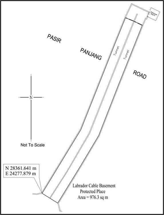
Labrador Cable Basement.
All that area comprised in part of Lot 3708A(pt) ‑MK03, along Pasir Panjang Road occupied by “Labrador Cable Basement” containing an area of about 976.3 square metres and bounded approximately as follows:
Commencing at the corner of the aforesaid “Labrador Cable Basement” which point is 28361.641 metres North and 24277.879 metres East of the Singapore Land Authority SVY 21 Datum, the boundaries run along successive lines of co‑ordinates approximately as follows:
Northing
Easting
28361.641
24277.879
28394.555
24298.011
28417.536
24307.181
28439.708
24316.004
28452.429
24321.199
28450.593
24325.608
28448.546
24329.921
28416.807
24317.184
28391.534
24307.279
28375.315
24297.556
28356.595
24285.988
to the point of commencement.
The boundaries of “Labrador Cable Basement” are more particularly delineated on the Survey Plan set out below.
First column
Second column
The Authority
Protected Place
Managing Director, SP Powergrid Ltd
(6)
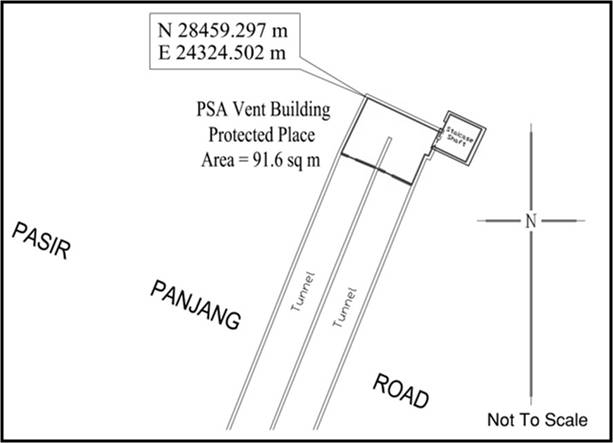
PSA Vent Building.
All that area comprised in part of Lot 3024W(pt) ‑MK03, along Pasir Panjang Road occupied by “PSA Vent Building” containing an area of about 91.6 square metres and bounded approximately as follows:
Commencing at the corner of the aforesaid “PSA Vent Building” which point is 28459.297 metres North and 24324.502 metres East of the Singapore Land Authority SVY 21 Datum, the boundaries run along successive lines of co‑ordinates approximately as follows:
Northing
Easting
28459.297
24324.502
28454.992
24333.576
28457.274
24334.674
28455.442
24338.586
28451.366
24336.602
28453.305
24332.567
28452.122
24332.002
28452.337
24331.558
28448.546
24329.921
28450.593
24325.608
28452.429
24321.199
to the point of commencement.
The boundaries of “PSA Vent Building” are more particularly delineated on the Survey Plan set out below.
First column
Second column
The Authority
Protected Place
Managing Director, SP Powergrid Ltd
(7)
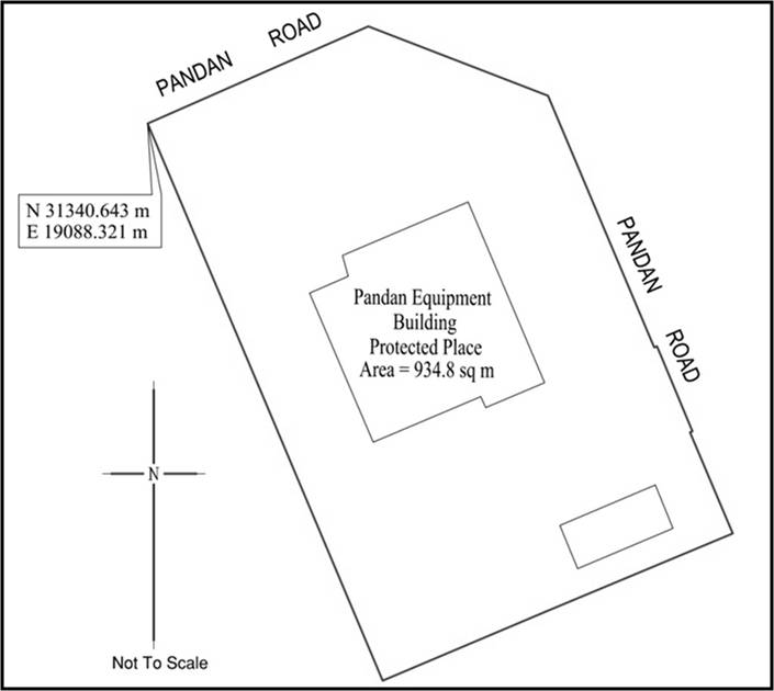
Pandan Equipment Building.
All that area comprised in part of Lot 7992K ‑MK05, along Pandan Road occupied by “Pandan Equipment Building” containing an area of about 934.8 square metres and bounded approximately as follows:
Commencing at the corner of the aforesaid “Pandan Equipment Building” which point is 31340.643 metres North and 19088.321 metres East of the Singapore Land Authority SVY 21 Datum, the boundaries run along successive lines of co‑ordinates approximately as follows:
Northing
Easting
31340.643
19088.321
31346.957
19102.648
31342.452
19114.321
31326.658
19120.992
31326.097
19121.229
31326.171
19121.402
31325.711
19121.598
31321.109
19123.513
31320.647
19123.706
31320.581
19123.550
31320.566
19123.556
31314.011
19126.326
31308.952
19114.219
31304.443
19103.588
31322.903
19092.816
to the point of commencement.
The boundaries of “Pandan Equipment Building” are more particularly delineated on the Survey Plan set out below.
First column
Second column
The Authority
Protected Place
Managing Director, SP Powergrid Ltd
(8)
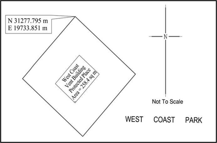
West Coast Vent Building.
All that area comprised in part of Lot 3751V ‑MK05, within the West Coast Park premises occupied by “West Coast Vent Building” containing an area of about 258.4 square metres and bounded approximately as follows:
Commencing at the corner of the aforesaid “West Coast Vent Building” which point is 31277.795 metres North and 19733.851 metres East of the Singapore Land Authority SVY 21 Datum, the boundaries run along successive lines of co‑ordinates approximately as follows:
Northing
Easting
31277.795
19733.851
31266.909
19745.974
31255.137
19735.362
31266.044
19723.253
31267.665
19724.717
31267.695
19724.744
31268.500
19725.412
31268.543
19725.449
to the point of commencement.
The boundaries of “West Coast Vent Building” are more particularly delineated on the Survey Plan set out below.
First column
Second column
The Authority
Protected Place
Managing Director, SP Powergrid Ltd
(9)
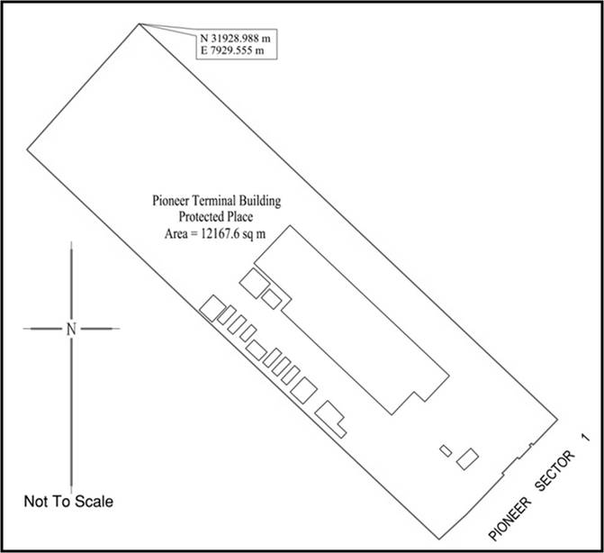
Pioneer Terminal Building.
All that area comprised in part of Lot 2924T ‑MK07, along Pioneer Sector 1 occupied by “Pioneer Terminal Building” containing an area of about 12167.6 square metres and bounded approximately as follows:
Commencing at the corner of the aforesaid “Pioneer Terminal Building” which point is 31928.988 metres North and 7929.555 metres East of the Singapore Land Authority SVY 21 Datum, the boundaries run along successive lines of co‑ordinates approximately as follows:
Northing
Easting
31928.988
7929.555
31911.966
7947.678
31894.550
7966.018
31869.436
7992.447
31788.702
8077.709
31788.432
8077.983
31788.195
8077.790
31779.417
8069.334
31780.015
8068.748
31779.369
8067.975
31778.775
8068.562
31774.428
8064.415
31774.418
8064.400
31775.001
8063.797
31774.995
8063.790
31774.575
8063.371
31774.577
8063.368
31770.204
8059.207
31770.053
8059.059
31770.032
8058.974
31769.393
8058.323
31768.746
8058.993
31759.653
8050.398
31754.225
8045.152
31754.267
8045.114
31745.807
8035.950
31745.916
8035.886
31765.662
8014.903
31780.037
7999.719
31813.292
7964.573
31829.307
7947.621
31846.521
7929.524
31866.778
7908.158
31883.664
7890.337
31884.236
7889.792
31884.740
7890.198
31899.306
7903.157
31915.839
7917.862
31922.846
7924.208
31924.417
7925.578
to the point of commencement.
The boundaries of “Pioneer Terminal Building” are more particularly delineated on the Survey Plan set out below.
First column
Second column
The Authority
Protected Place
Managing Director, SP Powergrid Ltd
(10)
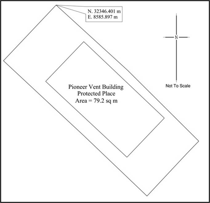
Pioneer Vent Building.
All that area comprised in part of Lots 3431C(pt) ‑MK07 and 3432M(pt)‑MK07, along Pioneer Sector 1 occupied by “Pioneer Vent Building” containing an area of about 79.2 square metres and bounded approximately as follows:
Commencing at the corner of the aforesaid “Pioneer Vent Building” which point is 32346.401 metres North and 8585.897 metres East of the Singapore Land Authority SVY 21 Datum, the boundaries run along successive lines of co‑ordinates approximately as follows:
Northing
Easting
32346.401
8585.897
32341.674
8591.067
32336.556
8596.207
32335.689
8595.370
32332.581
8592.463
32336.963
8587.885
32342.373
8582.090
to the point of commencement.
The boundaries of “Pioneer Vent Building” are more particularly delineated on the Survey Plan set out below.
First column
Second column
The Authority
Protected Place
Managing Director, SP Powergrid Ltd
(11)
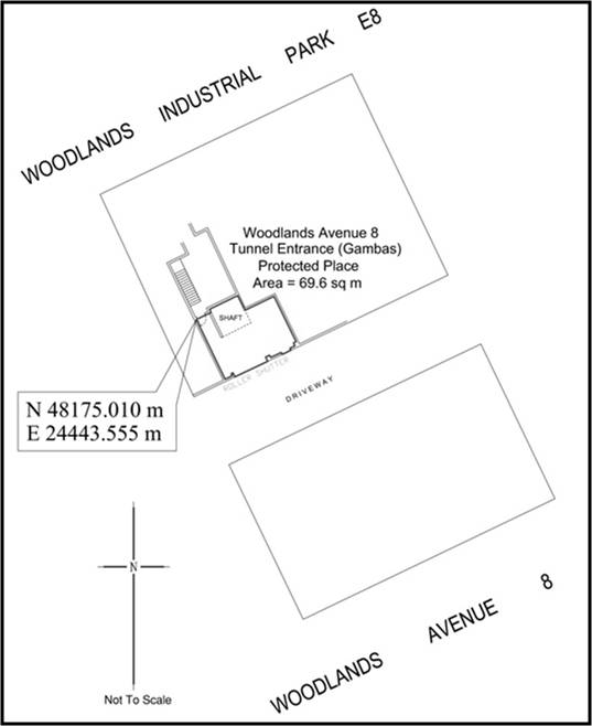
Woodlands Avenue 8 Tunnel Entrance (Gambas).
All that area comprised in part of Lot 4255L ‑MK13, along Woodlands Avenue 8 occupied by “Woodlands Avenue 8 Tunnel Entrance (Gambas)” containing an area of about 69.6 square metres and bounded approximately as follows:
Commencing at the corner of the aforesaid “Woodlands Avenue 8 Tunnel Entrance (Gambas)” which point is 48175.010 metres North and 24443.555 metres East of the Singapore Land Authority SVY 21 Datum, the boundaries run along successive lines of co‑ordinates approximately as follows:
Northing
Easting
48175.010
24443.555
48175.848
24445.274
48176.211
24445.096
48177.804
24448.396
48176.089
24449.232
48177.725
24452.635
48172.430
24455.217
48172.276
24454.914
48171.928
24455.090
48171.644
24454.495
48171.420
24454.607
48170.942
24453.605
48171.165
24453.493
48170.574
24452.256
48170.849
24452.117
48170.617
24451.662
48170.132
24451.909
48168.303
24448.052
48168.790
24447.845
48168.686
24447.629
48168.428
24447.738
48168.031
24446.920
to the point of commencement.
The boundaries of “Woodlands Avenue 8 Tunnel Entrance (Gambas)” are more particularly delineated on the Survey Plan set out below.
First column
Second column
The Authority
Protected Place
Managing Director, SP Powergrid Ltd
(12)
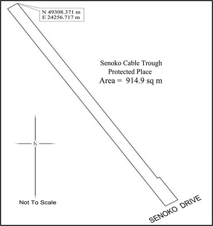
Senoko Cable Trough.
All that area comprised in part of Lot 1962L ‑MK13, along Senoko Drive occupied by “Senoko Cable Trough” containing an area of about 914.9 square metres and bounded approximately as follows:
Commencing at the corner of the aforesaid “Senoko Cable Trough” which point is 49308.371 metres North and 24256.717 metres East of the Singapore Land Authority SVY 21 Datum, the boundaries run along successive lines of co‑ordinates approximately as follows:
Northing
Easting
49308.371
24256.717
49306.804
24257.722
49286.542
24270.716
49263.509
24285.468
49240.492
24300.248
49217.486
24315.023
49198.575
24327.122
49198.626
24327.201
49198.710
24327.136
49199.192
24328.059
49199.257
24328.161
49186.728
24336.254
49185.661
24336.983
49185.072
24337.376
49181.094
24331.124
49195.306
24322.012
49207.879
24313.951
49220.451
24305.904
49235.106
24296.489
49249.763
24287.092
49266.505
24279.337
49279.067
24268.287
49287.454
24262.944
49297.927
24256.235
49304.929
24251.726
49307.287
24255.026
to the point of commencement.
The boundaries of “Senoko Cable Trough” are more particularly delineated on the Survey Plan set out below.